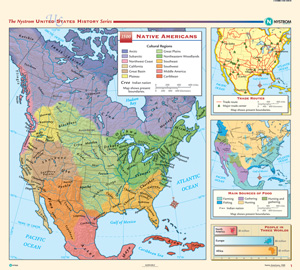
AMERICAN INDIANS, 1500
Map on spring roller with backboard
Connect with a representative to create a custom curriculum for your district.
The main part of the map identifies Indian nations in North America and uses color shading to delineate the general regions in which each nation was located. Insets show trade routes, main sources of food in different regions (farming, fishing, gathering, hunting, and hunting/gathering), and a bar chart that compares the total populations of North America, Europe, and Africa at the time.
This title is part of the series: THE NYSTROM COMPLETE U.S. HISTORY MAP SET


