INTERMEDIATE PHYSICAL MAP SERIES
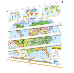
While shaded relief plainly reveals mountainous areas, colors classify terrain as forest, grassland, desert, or alpine. These maps are designed for students who have become familiar with cartographic conventions and now are ready for the most essential geographic information. Both show capital and major cities (with type size denoting population), landforms and water features, longitude and latitude, and inset thematic maps: rainfall, temperature, and land use. Other U.S. map insets include a locator map, Alaska, Hawaii, and a transcontinental cross-section elevation profile. Both maps measure 53″h x 65″w and are mounted together on one heavy-duty metal spring roller with a backboard.
See also:
This title is part of the series: INTERMEDIATE PHYSICAL MAP SERIES
| Size | |
|---|---|
| Publisher | Nystrom |
| Grade | 4–5 |
| ISBN | 9780782541151 |