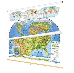
SCULPTURAL AND POLITICAL RELIEF DUAL MAP SET
4 maps on one roller with backboard
Connect with a representative to create a custom curriculum for your district.
Help students understand relationships between the physical world and its political divisions by comparing and contrasting pairs of U.S. and world maps from these two series.
Sculptural-relief maps use seven colors to dramatically distinguish elevations on land and three shades to suggest ocean depths, while political maps use contrasting colors to make political divisions easily visible. The political maps measure 54"h x 65"w, the world sculptural-relief map measures 54"h x 65"w, and the U.S. sculptural-relief map measures 72"h x 65"w. The four maps come mounted on a heavy-duty metal spring roller with a backboard.
| Publisher | Nystrom |
|---|---|
| ISBN | 9780782541687 |